In 1976, an organization called Bikecenntenial introduced the TransAmerica Trail, a bicycle route that spanned the country from Oregon to Virginia. The purpose was to celebrate America’s 200th birthday, while encouraging people to experience the United States at 10 to 15 miles an hour. Forty-six years later, Bikecenntenial has become the Adventure Cycling Association, with thousands of miles of new routes covering every state. It’s an interstate highway system for cyclists, but sticks to the quieter backroads for safety and solitude.
At first, I thought I’d ride the TransAmerica Trail, still the most popular choice for Americans and many foreign visitors. However, as I looked at the map other possibilities appeared. If this was going to be a ride to remember, I wanted to include things of personal interest, whether historical, natural, regional or man-made.
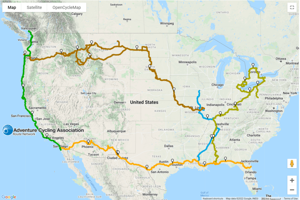
Having grown up in Florida, I considered that a logical starting point for an East to West crossing. Many cyclists begin on the West coast to take advantage of the prevailing winds, but local winds can come from any direction, so the effect on travel is marginal. As someone familiar with the southeast, I felt I’d be more motivated to pedal from the “known” of Florida to the “unknown” of the western states. To my benefit, there was a route that ran from Saint Augustine, Florida to San Diego, California, the Southern Tier, which looked like a good place to start. Saint Augustine, founded in 1565, was a major Spanish settlement in the New World, with a large fort, Castillo de San Marcos, that remains today as evidence of its importance to early settlers
Tracing the Southern Tier westward, there was an Underground Railroad connection in Mobile, which would take me north through Alabama and Mississippi. Because the route eventually bends towards the northeast, ending in Montreal, continuing along that path wasn’t an option. However, following the Mississippi River was.
The Great Rivers South route runs along the Mississippi from Iowa to Louisiana, closely following the river to New Orleans. To me, there isn’t a more historic river except, perhaps, the Nile. But, what the Mississippi lacks in pyramids and temples, it makes up for in pure impact on our country. As Mark Twain wrote in “Life on the Mississippi“, “The Mississippi is well worth reading about. It is not a commonplace river, but on the contrary, is in all ways remarkable. Considering the Missouri, its main branch, it is the longest river in the world-four thousand three hundred miles.” Following portions of the Natchez Trace Parkway along the way, this would take me as far as Saint Louis.
In 1804, thirty-one years before Mark Twain was born, Meriwether Lewis and William Clark navigated the Missouri River to the west, eventually winding up on the coast of Oregon with their “Corps of Discovery”. Their mission, assigned by President Jefferson, was to investigate the land acquired through the Louisiana Purchase. Leaving from a point near Hartford, Illinois, about 17 miles north of Saint Louis, they returned about two years later with objects of interest gathered along the way and stories to tell.
When I saw that the Adventure Cycling Association’s Lewis and Clark Trail would let me follow in their footsteps all the way to Oregon, that was it for me. There was no other route that had such a narrative connected with it, nor was so important to our early history. In places, the land remains much as Lewis and Clark saw it over two hundred years ago, and the attraction of chasing their ghosts to the Pacific can’t be denied.
The title of this blog is “Saint Augustine to Seattle”, but I’ll be in Seaside, Oregon at the end of the Lewis and Clark Trail, and have traveled from the Atlantic to the Pacific. So, why finish in Seattle? The short answer is to wrap things up in a meaningful way. Following a section of the Pacific Coast Route, my destination in Seattle will be the Space Needle, built for the 1962 World’s Fair. Between Castillo de San Marcos and the Space Needle, there’s a timeline that spans nearly 400 years. The last miles of the ride will take me to a 20th century icon, before I return to the 21st century and whatever lies ahead.